
Finding Liminality in Landscapes: Exploring Iceland
- Oct 28, 2025
- 8 min read
Article by Pepijn Hoffard
Edited by Jorunn Schaftenaar
I have found myself on an interesting island in the middle of the Atlantic Ocean.
This country, with steep peaks crashing into the oceans, never-ending plains, colourful mountains, massive glaciers, lava fields and geysers spewing constantly, leaves quite the impression. Yet, aside from its beauty, there is something odd about many of its landscapes. It makes me wonder, why does Iceland feel so liminal?

Figure 1: A camping playground found in Rauðisandur, Vestfirðir (Westfjords). (Photo: author, 2025)
Natural, but liminal
Whilst there are many definitions of liminality (For a better definition, see the article: ‘A Recipe For Making Liminal Spaces’ as written by Ian Witte), I often describe it as a space or landscape which enlists a feeling of unease. Often, these are spaces too perfect to be real, or strangely unused. Many of these spaces are made by humans, but seemingly not used anymore. To me, a liminal space bears human touch in a way that makes it feel unnatural. So, how can such a natural landscape, such as Iceland, be liminal? And how can a whole landscape make you feel uneasy?
Iceland is one of the most spectacular countries I have been to. What makes it so impressive is its vast, never-ending landscapes, with little to no large vegetation (Figure 2). The lack of trees is specifically noteworthy, as this makes you able to actually see the huge natural landscapes. Well, I say natural, but the lack of trees is a bit suspicious. Iceland used to have, before the settlers around the year 1000 A.C., many trees and forests. Speculated is that Iceland had a forest cover of about 30-40%, yet now it is only about 2%. This, of course, can only be achieved by human influence.

Figure 2: An unused road in wintertime near Þingvellir National Park. (Photo: Ian Witte, 2022)
When the first settlers came, they came on this cold, birch-covered island. Especially in winter it can be quite tough without a heat source. So, they cut the birch trees for their fires to keep themselves warm. Yet, this is not why all the forests have disappeared. Their impact of cutting trees for heating was quite limited. The actual problem was food.
As a subarctic island, crops are not as easily available. Luckily, grass grows everywhere, but for humans grass is not so useful to eat. Yet, livestock, and especially sheep, can thrive on grass. So, the first settlers brought many sheep and created fields for hay production. To make space for the fields, they cut down the birch forests covering the land. This removed most of the lowland birch forests. Aside from being cut down, the birch trees had some additional bad luck. The young sprouts and leaves are delicious snacks for sheep to mix up their diet. This, in addition to harsh growing conditions in the subarctic, caused forests to decline and not being able to reestablish.
The Icelandic landscapes are thus very much created. When you look over the open lands, seeing dust being blown by the wind, you wonder what it would have looked like if it remained vegetated (Figure 3). Would it feel less strange if these deserts were filled with forests? The barren lands show me a sign of dissonance between humans and nature, yet for many Icelanders, these open landscapes have always been part of life. They simply see them as home.

Figure 3: A desert found in the middle of the Icelandic highlands, close to Landmannalaugar. (Photo: author, 2022)
Fisheries and abandonment
After the sheep shaped the country, other signs of human impact started to appear. With infrastructure, buildings and towns, the country shows usage. Sheep farmers are still active, but new ways of surviving and progressing are explored. One industry seems to become important: the fishing industry.
With a rise of the fishing industry, towns close to the sea are established and developed. The establishment even happens on seemingly illogical and hard-to-reach areas. But fish is fish, and fish is profit. Yet not every fishery town is created equally, and some suffer because of the rough conditions and the hard winter. As fast towns are established, so are some left behind.
Djupavík is such a town, effectively abandoned as the fisheries declined (Figure 4). This town is situated in a deep fjord, far from any larger towns. Its distance from a market makes it hard to maintain economically, and this is (most likely) the reason for the abandonment.

Figure 4: Abandoned ships and materials in Djúpavík. (Photo: author, 2022)
Coming from the Netherlands, seeing abandoned places is strange. It is not something you would (easily) find in our country. We use all our spaces very efficiently. When something is not used, we replace it with something else. In Iceland space is not so much an issue. It’s a big country and not a lot of people. So, removing old unused stuff is more trouble than it’s worth. Why bother, if you can easily move to a place which is not being used yet. This is why you can see ghost towns and just random stranded ships on the more excluded areas of the country (Figure 5).
Even though us dutchies might consider leaving material and space behind as wasteful, these forgotten locations do create a fantastic sight. They are strangely nostalgic and deeply liminal. You can imagine the ghost towns, back when they were filled with people living their lives, as a functional town full of opportunities. Yet now the old dreams are turned into old scraps and rubble left to wither. A place once made by humans, not used by humans anymore.

Figure 5: Stranded ship (Garðar BA 64) in Sauðlauksdalur, Vestfirðir. (Photo: Jorunn Schaftenaar, 2025)
Natural disasters
One thing I have not touched upon yet is something so inherent to this Atlantic island: natural disasters. As a volcanic island, it is prone to eruptions, earthquakes and complimentary disasters. Though destructive, Iceland has been shaped by it. Mother earth, with its molten rock, has created some of the most impressive landscapes found in Europe, and also some of the most liminal. Large volcanos, geothermal areas, and earthquake cracks can be deeply strange, the most liminal landscape, I believe, are the floodplains found in the South of Iceland.
Floodplains sound silly when just introducing the notion of volcanism, yet they are related. These floodplains are only possible because of another interesting fact of Iceland: Iceland has the largest subarctic glaciers in the world. Below these massive glaciers are also some of Iceland’s largest volcanos. When such a slumbering giant gets awoken and pushes more than 1000 degrees molten rock through the crust of the earth and this rock meets 400 meters of ice, disaster ensues. Even though the ice is thick, the eruption blows through it quickly, melting a hole in the glacier.
The now molten ice must go somewhere. With its massive volume it ploughs paths through and under the glacier, bringing along everything it comes across. When the water and rubble reach the lowlands, it spreads creating these huge floodplains. After settling, what is left are these fully black plains, stretching further than the eye could see (Figure 6).
These homogenous, never-ending floodplains might be one of the most liminal landscapes in Iceland. You are standing in infinite black plains looking towards the sea, hoping to get a glimpse of where it should start. Yet, the blackness turns into the sky, without a sign of where the sand turns into waves.
To get an idea of the force it takes to create such a landscape, there is footage of such a flood happening in 1996 with an eruption called Gjálp (https://www.youtube.com/watch?v=f_ksPgJCbzA).
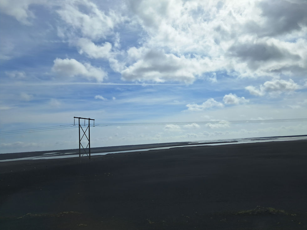
Figure 6: The floodplains from Vatnajökull in the South of Iceland. This is taken from the highway between Kálfafell and Skaftafell. (Photo: author, 2025)
Grindavík
Let me finally touch upon a place which combines the previous examples given. The place is another abandoned town, yet it is a little different. Because the abandoned places that I have talked about were old towns that had unfortunate economics, making it unsustainable. On the contrary, Grindavík was a fully functioning town until 2023. It had great development in the fishing industry. Additionally tourism was also becoming a large business, as the town is advantageously located on the Reykjanes Peninsula, basically between the airport and Reykjavík. Yet in October of 2023, the earthquakes started to happen. With more than 20.000 earthquakes within a month, it was clear that an eruption was impending.
The town had been fully evacuated in December, when the eruption was imminent. The fissure created by the magma luckily did not hit the town; it had spawned far enough north. But the town was still damaged by the earthquakes, causing cracks in paths, streets, golf fields and large buildings. Fortunately, the worst did not happen: the town was not hit by flowing lava. The citizens of Grindavík hoped to get back to their lives as soon as the eruption settled… yet it never did.
In January 2024 the second eruption began North of Grindavík. With new fissures spewing lava, the town was kept empty. This time a small fissure opened almost below the town, causing the destruction of three houses. Although this was a quick eruption, it was speculated these were the first of many.
Well, they did not need to speculate much. In February another eruption happened, and then also in March, and in May, and June, August, September, November… until this 2025 summer. There have been 9 eruptions in about a year and a half, accompanied by near constant earthquakes. Most people left the town completely, after not being able to stay longer than a month before being evacuated again, all whilst constantly shaking. It has become effectively abandoned.
It is truly strange to see a modern town turned into a ghost town so recently. As of last summer, almost no people were living here. The shops were closed, the streets were blocked off and the houses were empty. It is deeply strange and sad to see newly built houses left empty (Figure 7). I feel for the people that are forced out of their homes.

Figure 7: An abandoned street in Grindavík after a series of eruptions from 2023-2025. (Photo: author, 2025)
Right after we left Grindavík for a trip towards the North of Iceland, another eruption close to the town started. We were on an old farm visiting some friends of mine when a sudden blue haze filled the air (Figure 8). Apparently, the eruption was spewing smoke and particles, covering the country in a smog. It reached us in a day, 200 kilometres away from the fissure. This was the first time I ever was close enough to a natural disaster that I had to deal with the impacts it had. We had to start wearing face masks, as the air was too polluted. Also, my first workday was cancelled due to air pollution from an eruption, how bizarre.

Figure 8: A blue haze covering the farm and church (Eyrarkirkja) in Seyðisfjörður. (Photo: author, 2025)
Concluding
Remembering my journey across the country has shown me things I hadn’t perceived prior. Seeing old forests as deserts, ruins of fisheries as forgotten lives, broken towns as memories of a time past and floodplains as newly created land. What connects these memories, is an always changing environment. Humans and nature keep reshaping the landscapes, forever stuck in transition. Maybe that is what makes Iceland so deeply liminal: a façade of stability, where beauty is found in uncertainty.

Figure 9: A view of the mountain range behind the town Hvanneyri. (Photo: author, 2022)


Comments